 geo.be Metadata Catalog
marine monitoring
Type of resources
Available actions
Topics
INSPIRE themes
federalThemes
Keywords
Contact for the resource
Provided by
Years
Formats
Representation types
Update frequencies
Service types
-

This web service allows viewing the datasets under the Marine Strategy Framework Directive (MSFD).
-

This dataset is part of the 2018 Belgian submission for the Marine Strategy Framework Directive (MSFD) linked to descriptor 6, criterion 1. This dataset describes and maps the the physical loss of the seabed in the Belgian part of the North Sea (BPNS) in the period 2011-2016. The dataset combines the different human activities responsible for a loss of seabed, including wrecks, measuring piles and radar stations, pipelines, power and telecommunication cables with their rock dump, and wind farms. The area lost is mapped and quantified per year, per activity and per benthic broad habitat.
-
This dataset is part of the 2018 Belgian submission for the Marine Strategy Framework Directive (MSFD) linked to descriptor 6, criterion 2. This dataset describes and maps the physical disturbance to the seabed in the Belgian part of the North Sea (BPNS) between 2011 and 2016. The dataset combines different layers of human activities leading to a disturbance of the seabed, including power cables with its rock dump, dredging and dumping, extraction, war ammunition stocking and wind farms. The area disturbed is mapped and quantified per year, per activity and per benthic broad habitat.
-
This dataset is part of the 2018 Belgian submission for the Marine Strategy Framework Directive (MSFD) linked to descriptor 8, criterion 3. This dataset gives an overview of the observed slicks during aerial survey operations of the Belgian part of the North Sea (2011-2016). Related to significant acute pollution, it includes the observations linked to the Flinterstar incident in 2015. Besides this, all observations of illegal discharges of MARPOL (International Convention for the Prevention of Pollution from Ships) annex I and II substances are included as an additional dataset.
-
This dataset is part of the 2018 Belgian submission for the Marine Strategy Framework Directive (MSFD) linked to descriptor 11, criterion 1. This dataset describes the impulsive noise generated during percussion pile emplacement for offshore wind farm construction and unexploded ordnance (UxO) explosions. Impulsive underwater sound (pressure) was measured during pile driving operations in Belgian waters, for different types of foundations (monopiles of different diameters, foundations of ducts with a smaller diameter) and hydraulic hammers with different energy powers. The results of measurements at Bligh Bank and Thornton Bank, with a resulting extrapolation of zero to peak noise level (Lz-p) at 750m and Sound Exposure Level (SEL) (no mitigation measures deployed), are presented (Norro et al., 2013).
-
This dataset is part of the 2018 Belgian submission for the Marine Strategy Framework Directive (MSFD) linked to descriptor 1, criterion 1. Stranded porpoises often show traces of incidental catch in fishing nets (bycatch), a major cause of death for this cetacean in the North Sea. Based on the number of stranded animals showing traces of bycatch, it can be estimated that up to a few dozen porpoises are caught per year. For extrapolation of bycatch data to effects at population level, reference is made to (future) initiatives at regional level.
-
This dataset is part of the 2018 Belgian submission for the Marine Strategy Framework Directive (MSFD) linked to descriptor 8, criterion 1. This dataset describes the contaminant concentrations in biota. The priority substances mercury, hexachlorobutadiene and hexachlorobenzene are measured in mussels and flounder in the BPNS. Results for other parameters that are part of the OSPAR Coordinated Environmental Monitoring Program are also included: polychlorinated biphenyls (PCBs), polycyclic aromatic hydrocarbons (PAHs), heavy metals, organotin-compounds and polybrominated diphenyl ethers (PBDEs) for the period 2011-2016. The analyses are performed by ILVO and KBIN-OD Nature that both participate in the Quasimeme ring tests for additional quality control. Bird eggs of 2008, 2010 and 2015 are measured for mercury (Hg), dichlorodiphenyltrichloroethane (DDT), hexachlorobenzene (HCB) and hexachlorocyclohexane (HCH). Eggs from the are measured and compared with OSPAR norms Common Tern (Sterna hirundo) are gathered in Zeebrugge and are analyzed by the Insitut für vogelforschung in Wilhelmshaven according to a standard protocol.
-
This dataset is part of the 2018 Belgian submission for the Marine Strategy Framework Directive (MSFD) linked to descriptor 8, criterion 1. This dataset is part of the 2018 Belgian submission for the Marine Strategy Framework Directive (MSFD) linked to descriptor 8, criterion 1. This dataset contains the concentrations of priority substances (tributyltin, polycyclic aromatic hydrocarbons (PAHs) and polybrominated diphenylethers (PBDEs)) measured in the water column at three stations in the Belgian part of the North Sea between 2009 and 2014 (as reported in the frame of the WFD in 2016). In total, 45 different parameters are measured.
-
This dataset is part of the 2018 Belgian submission for the Marine Strategy Framework Directive (MSFD) linked to descriptor 8, criterion 2. This dataset contains measurements on the 7-Ethoxyresorufin-O-deethylase (EROD) activity in Limanda limanda, Imposex (OTIN in Mytilus edulis), fish diseases and counts of oiled common guillemots in the Belgian part of the North Sea.
-
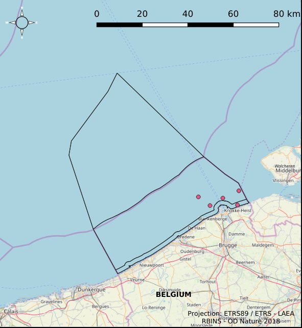
The Royal Decree of 22 May 2019 establishing a marine spatial plan defines 6 measuring poles: Measuring pole MOW.0 (Art. 21§2), Measuring pole MOW.1 (Art. 21§2), Measuring pole MOW.2 (Art. 21§2), Measuring pole MOW.3 (Art. 21§2), Measuring pole MOW.4 (Art. 21§2), Measuring pole Westhinder (Art. 21§2). It replaces the 2014 Marine Spatial Plan, which is included for completeness. The Royal Decree of 20 March 2014 establishing a marine spatial plan defines in its Art. 15. §3, one set of measuring pole locations. These locations are made available digitally in the resource described by this metadata document. Please refer to the Belgian official gazette (\"Moniteur belge/Belgisch Staatsblad\") for official reference information.